
Mississippi State University's Geosystems Research Institute UAS Maps Deer Island for Mississippi Secretary of State and Department of Marine Sciences
June 30, 2016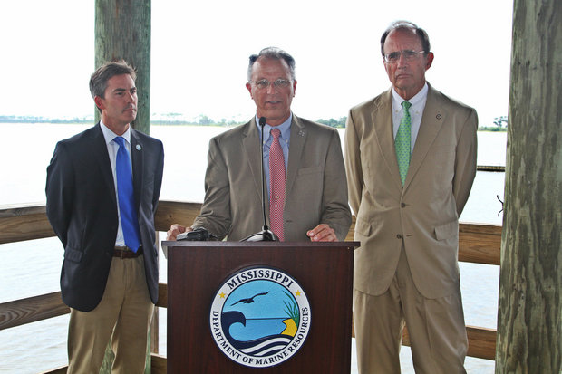
L to R: Jamie Miller, Executive Director of Department of Marine Resources, Dr. Robert Moorhead, Director of the Geosystems Institute at Mississippi State University, and Secretary of State, Delbert Hosemann convene for a press conference to discuss the mapping of Deer Island in Biloxi. (Photo by Tyler Carter)
tcarter@al.com
Mississippi Press/AL.
BILOXI, Miss. – Mississippi Secretary of State Delbert Hosemann, along with the Department of Marine Resources and Geosystems Research Institute at Mississippi State University, gathered Wednesday to preview results gathered from drone mapping of Deer Island.
Hosemann began discussing the importance of taking advantage of the amenities Biloxi can offer to tourists and the importance in trying to convince tourists to stay a day longer than originally planned.
"Today is a good day," Hosemann said. "Mississippi acquired all of the island you see behind you about 15 years ago and that debt was paid off two years ago. Now it is free, clear, and owned by the state of Mississippi. It is a phenomenal jewel and with that, we believed that we needed to map the island entirely and provide for the citizens and tourists a detailed, visual presentation of what is available to them. Further, this mapping will show the island undergoing improvements, along with the great barrier islands that are not only a key in storm prevention, but also serves as a key for tourism and recreation."
"This coincides with the small part Jamie and I play in getting people to stay one more time on the Gulf Coast," Hosemann said. "It's worth tens of millions of dollars to have people stay one more day and the way you do that is by providing them with a 'cafeteria' of options here."
"You can go to the casino or to the baseball game, you can go to your own island, or you can go offshore, or you can play golf at a world class venue, we have all these things here on the Mississippi Gulf Coast and if we can get people to stay for an extra day at your island, it will be a huge economic benefit to your city and the state of Mississippi," Hosemann said.
Hosemann said that while listening to the radio one day, he heard about the drone program Mississippi State had, which led to him to make the call to MSU to see if they would be interested in putting their expertise to use for a Deer Island mapping project. MSU agreed and the filming of the island ensued.
According to Jamie Miller, Executive Director of the Department of Marine Resources, Deer Island is an active restoration site and the
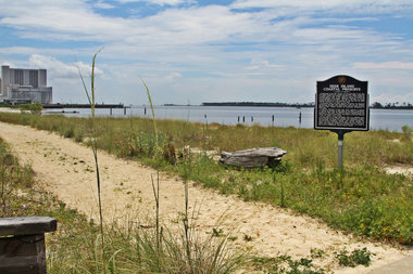
Deer Island located in Biloxi, MS (Photo by Tyler Carter)
"Since I have been here, Secretary Hosemann has really led in wanting to feature this island and really make sure that we are being great stewards of Mississippi's resources," Miller said.
"Mississippi State's unmanned aerial systems did their due diligence in not just taking really good pictures and video, but actually help us manage vegetation and annually looking at what island may be experiencing changes so that we can do adaptive management to make sure that we are prepared for that," Miller said.
Miller said continuous improvements to the island, such as the addition of a pier, allow for more tourists to be introduced to it.
"We were very happy to partner with the Secretary of State's office and MSU to get this work done and we look forward to continue our relationship moving forward and we hope will visit the island and remember that it is a coastal treasure undergoing restoration because we want to keep it that way for a long, long time," Miller said.
Director of the Geosystems Research Institute, Dr. Robert Moorhead, described the process by which he and his team were able to compile images. It included working with Keesler Air Force Base to allow the drones to fly in their airspace to obtain the best high resolution images possible to put together a map.
According to Miller, while the island is still an active restoration site, the Department of Marines Resources is asking for people to stay away from certain sites that are under restoration. Citizens or tourists are also not allowed to remain on the island overnight.
Biloxi Mayor Andrew 'Fofo' Gilich said today was a step in the right direction for the city.
"It's another opportunity for the visitors and people we treasure the most," Gilich said. "The people who visit this place totaling about 5.7 million visitors a year are provided with the opportunity to experience all that we have to offer here. As a young boy, I visited the island and I swam through it a number of times and it is a great treasure and now it available to the everyday tourist which provides a tremendous opportunity for us and our tourism industry."
MSU drones footage captures beauty | Sun Herald