
After the Burn: Using UAS to Monitor and Manage Forest Restoration
March 18, 2016Biologists and geographic information system specialists from the Grand Bay National Estuarine Research Reserve, along with the U.S. Forestry Service, are assessing the land and habitat that recently burned as a result of a large wildfire that spread across southeast Jackson County into Alabama. These experts are working with Mississippi State's Geosystems Research Institute to survey the after
 burn of more than 4,200 acres. In a few hours, GRI's unmanned aerial systems are able to capture imagery of the remote, wild, woodlands and marsh of GBNERR, the Grand Bay National Wildlife Refuge and other adjacent lands.
Lindsay Spurrier, a geographic information specialist with GBNERR, said before they used unmanned aerial vehicles to help them learn more about the importance of fire to restore habitats, their studies were limited by imperfect evidence.
"A crew of field biologists would spend weeks trying to hike to remote spots within the upland pines and across the marsh to gather enough data to get a good sample of vegetation post burn," Spurrier explained. "The imagery taken from the unmanned aerial vehicles gives us in almost real time the changes in the trees and vegetation, along with showing the density and regrowth."
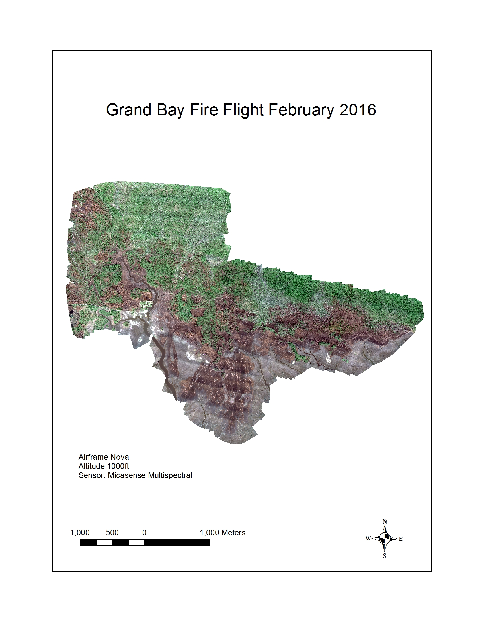
The Altavian Nova Block III scanned the area at 1,000 feet and used a MicaSense RedEdge five-band sensor device to capture the biodiversity of vegetation health and in precise detail the areas of upland and marsh that burned.
Robert Moorhead, director of GRI, said, "The MicaSense RedEdge is multispectral sensor. It can sense energy at five different wavelengths with two of those wavelengths beyond our own vision in the Near Infrared (NIR) region of the electromagnetic spectrum."
"NIR is great for studying the status of the living vegetation," added Louis Wasson, GRI Remote Sensing expert. "Researchers no longer have to guess about the status of biodiversity restoration. The multispectral sensor provides precise data that gives researchers the status of vegetation extent and the areas under stress in the coastal ecosystem."
UAS is becoming a popular tool for land managers and researchers because it gives them easy access to all the land they are tasked with managing.
"It is important because it can show us where there are dense, thick stands of trees that compete with new plants for water and nutrients," Spurrier offered. "These mosaicked images help us determine where to conduct prescription burning to create an opening to let more light filter in and spur new vegetation growth."
Grand Bay NERR is a state-federal partnership with the Mississippi Department of Marine Resources and the National Oceanographic and Atmospheric Administration's Office for Coastal Management. GBNERR is one of 28 NERRs nationwide. For more information please visit https://grandbaynerr.org/
For more information about Mississippi State University's GRI UAS research program, please visit https://www.gri.msstate.edu/rsearch/sensors_modeling.php#179.